Table of Contents >> Show >> Hide
- What Ford and Google actually did
- Why the TransAmerica Trail has such a big reputation
- Why this is a smart move for Google Street View
- Why Ford was the perfect partner
- What this changes for overlanders and trail dreamers
- The stewardship question nobody should ignore
- What this project says about American adventure right now
- The experience of the trail now: what people will actually feel
- Final thoughts
There are road trips, there are off-road trips, and then there is the kind of adventure that makes your suspension file a formal complaint. That is the lane Ford and Google chose when they teamed up to map the TransAmerica Trail for Google Street View. In plain English: one of America’s most legendary overlanding routes is no longer just something whispered about in forums, GPX files, and campfire lore. Now, it is something you can scout from your phone.
The headline sounds like a shiny little brand collaboration, and sure, there is some of that. Ford gets to show off its off-road credibility. Google gets to expand Street View far beyond suburban culbs-de-sac and tourist hotspots. But the bigger story is what this means for access. The TransAmerica Trail, or TAT, has long been a bucket-list route for serious riders and overlanders because it links remote backroads, dirt tracks, mountain passes, forest routes, and desert sections into a coast-to-coast journey. It is big, it is rough, it is beautiful, and it has historically rewarded the prepared while punishing the clueless.
That is why this mapping project matters. It is not just a cool tech stunt with a Bronco wearing a camera hat. It is a digital doorway into a trail system that has always felt a little mysterious. For veteran off-roaders, that means better trip planning. For curious newcomers, it means fewer blind guesses. And for armchair adventurers, it means you can now explore one of the country’s wildest routes without getting dust in your teeth. A tragedy, perhaps, but a convenient one.
What Ford and Google actually did
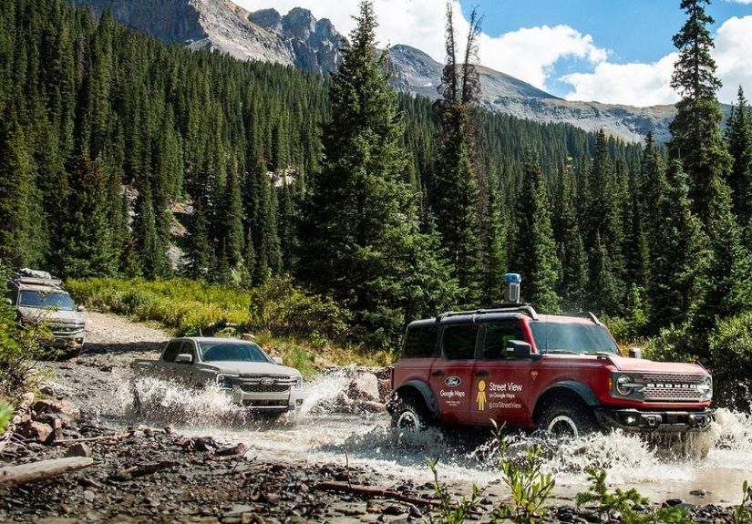
Ford and Google mapped the full TransAmerica Trail for Google Street View, turning a famously rugged off-road route into something anyone can preview online. The route stretches for more than 5,900 miles, crosses 13 states, and runs from the Pacific Northwest to the Atlantic coast. That alone makes the project notable. Street View has covered roads, landmarks, and trails before, but putting an entire coast-to-coast off-road route onto the platform is a different kind of flex.
The convoy itself was wonderfully practical. A Ford Bronco Badlands served as the lead capture vehicle, carrying Google’s Street View camera system. Behind it came a Ford Ranger Lariat and a Ford Expedition Tremor, which handled crew support, gear, recovery tasks, camp logistics, and all the unglamorous work that makes glamorous adventure footage possible. Over roughly a month on the trail, the team crossed forests, desert sections, rocky climbs, river-adjacent roads, and steep mountain terrain to collect panoramic imagery from Oregon all the way to North Carolina.
That support setup matters because mapping a trail like this is not remotely the same as driving a camera car down a paved boulevard. Off-road mapping means washouts, route adjustments, unpredictable weather, loose rock, mud, livestock, narrow shelf roads, and long stretches where “nearby services” is just a fancy phrase for “good luck.” Ford’s vehicles were not there as props. They were there because the trail asks real questions, and the convoy needed real answers.
Why the TransAmerica Trail has such a big reputation
The TransAmerica Trail is not iconic in the polished, postcard, gift-shop sense. It is iconic in the way only backcountry routes can be: among the people who know, it is legendary. Originally developed by Sam Correro, the TAT became famous because it offered a way to cross huge parts of the country while staying off pavement as much as possible. It pieced together public roads, forest service routes, backcountry connectors, and forgotten rural pathways into a journey that feels less like commuting and more like discovering America’s hidden operating system.
That matters because modern travel has become painfully efficient. The interstate gets you there quickly, but it also turns the country into a blur of chain gas stations, exit ramps, and regrettable convenience-store sandwiches. The TAT does the opposite. It forces you into small towns, weather changes, elevation swings, and terrain that actually demands attention. You do not just pass through the landscape; you negotiate with it.
It also has a reputation for being difficult to navigate, especially for first-timers. The trail is not a single neatly signed path with giant arrows and helpful snack bars every 20 miles. It has long required good maps, solid preparation, route awareness, and the humility to admit when conditions have changed. In that sense, the TAT has always been part adventure and part homework assignment. Ford and Google did not remove that challenge, but they did lower the barrier to understanding what the route looks like before you commit to it.
Why this is a smart move for Google Street View
For Google, the project shows how Street View keeps evolving from a road-navigation novelty into a broader visual layer for the real world. Street View is no longer just about seeing what a coffee shop looks like from the curb. It is increasingly a tool for context. It helps people understand terrain, access, road conditions, landmarks, and the character of a place before they ever arrive. Mapping a route like the TAT expands that idea into the off-road universe.
And that universe is a perfect fit for panoramic imagery. Off-road travel is intensely visual. You want to know whether a trail narrows near a cliff edge, whether the surface turns from gravel to rock, how exposed a mountain pass looks, and whether “water crossing” means “cute little splash” or “time to question every life decision that brought you here.” Street View cannot replace judgment, weather awareness, or local conditions, but it can give people a much better feel for what lies ahead.
It also gives Google something more subtle: cultural relevance. Mapping a famous off-road route says the company understands that not all mobility happens in cities, on highways, or around commercial districts. Some of it happens where there is dust, no cell signal, and one suspicious cow staring at you like you owe it money.
Why Ford was the perfect partner
Ford’s role in this project was more than convenient product placement. The company has spent the past several years leaning hard into outdoor identity, especially with the Bronco, Ranger, and Tremor sub-brands. Those vehicles are marketed not just as transportation, but as gear for exploration. By helping map the TransAmerica Trail, Ford turned that messaging into a real-world demonstration. It is one thing to say a vehicle is trail-ready in a commercial. It is another thing to send it across a 5,900-mile off-road route with expensive camera equipment bolted on top.
The Bronco Badlands, in particular, makes symbolic sense here. The vehicle has become Ford’s halo model for serious off-pavement credibility, and using it as the image-capture vehicle reinforces the idea that the Bronco is not just styled for adventure, but built for it. The Ranger and Expedition also fit the story well because real expeditions need more than a hero vehicle. They need cargo space, recovery capability, camp support, towing muscle, and room for the team to function like something more organized than a very dusty group chat.
What this changes for overlanders and trail dreamers
The biggest benefit of mapping the TransAmerica Trail is not that it makes the route easier. It is that it makes the route more legible. That is a huge difference. Experienced off-roaders know that the hardest part of many routes is not always the terrain itself. Sometimes it is the uncertainty before the terrain begins. What is the road surface like? How exposed is that section? Is the obstacle rocky, rutted, sandy, or all three at once because the universe enjoys variety?
With Street View coverage, would-be travelers can preview sections of the route in advance, identify terrain that may be above their comfort level, and better plan vehicle setup, timing, fuel stops, and gear. A family in a stock 4×4 can see whether a section looks manageable. A motorcycle rider can study a route before committing to it. A newcomer can learn what “remote” really looks like when it is not filtered through cinematic drone footage and dramatic soundtrack music.
This also broadens the audience. Before, the TAT often felt like an insiders’ route, something you earned access to through experience and community knowledge. Now it becomes more approachable without being watered down. That is a meaningful shift. Good access is not about turning adventure into a theme park. It is about making information better so decisions can be smarter.
The stewardship question nobody should ignore
Of course, accessibility is not automatically good if it leads to careless use. Every time a beautiful route becomes easier to find, it also becomes easier to misuse. That is the tension built into this story. The same technology that helps people plan responsibly can also send underprepared drivers into terrain they should not be touching. Off-road culture has learned this lesson before, usually the hard way and often with torn-up land left behind.
That is why the stewardship angle is not just a footnote. It is central. Organizations like Tread Lightly, along with federal land managers such as the Bureau of Land Management and the U.S. Forest Service, have long pushed the same core principles: stay on designated routes, avoid widening trails, respect private property, protect wildlife and livestock, avoid damaging wet terrain, and pack out what you bring in. In other words, do not turn somebody else’s future adventure into your current mess.
Ford’s own storytelling around the project leaned into those ideas, and that was the right move. The best outcome here is not simply more traffic on the TAT. It is better-informed traffic. If Street View helps people choose the right season, the right vehicle, the right route variation, and the right expectations, then it could actually reduce some of the sloppy mistakes that happen when people roll into backcountry terrain powered by optimism and absolutely no clue.
What this project says about American adventure right now
There is also something quietly revealing about why this story resonates. Americans are still deeply attracted to the idea of wandering into big open country, even if they first do it through a screen. The appetite for overlanding, dispersed camping, trail travel, and off-grid exploration has not gone away. If anything, it has become more mainstream. People want experiences that feel less scripted, less crowded, and less algorithmically optimized. They want to feel like there is still some room left for surprise.
The Ford-and-Google partnership taps directly into that mood. It blends digital convenience with analog aspiration. You can scout the route online, zoom into a mountain pass, and examine an empty desert stretch from your couch. But the imagery also reminds you that the real thing is still out there, waiting with wind, dust, altitude, and the occasional deeply inconvenient obstacle. Technology, in this case, does not replace adventure. It teases it.
The experience of the trail now: what people will actually feel
From Oregon’s trees to your laptop screen
One of the strangest and coolest parts of this project is how well it can transmit mood. Start at the western end of the route and you immediately get why the TAT has such a hold on people. The landscape feels less like a line on a map and more like a living sequence of textures. Forest roads in Oregon carry that damp, green, early-morning feeling that makes every off-road trip seem noble before your coffee gets cold. The trail looks inviting, but never lazy. You can almost sense the shift from pavement logic to trail logic: slower pace, sharper observation, less certainty, more reward.
For a viewer on Street View, that matters. It turns abstract adventure into something tangible. You are not just reading “forest route” on a forum. You are seeing the width of the road, the surface, the tree line, the light. You start thinking like a traveler instead of a spectator. That kind of visual familiarity can calm nerves before a trip or, just as importantly, warn someone that a section might be more than they bargained for.
Utah and the art of feeling tiny
Then come the Western expanses, where the trail starts doing what great American landscapes always do: making human beings look hilariously temporary. Utah’s open sections, red rock zones, and desert reaches have a way of stripping travel down to essentials. Sky. Earth. Vehicle. Water. Judgment. Repeat. Even on a screen, the emptiness reads clearly. You understand why overlanders love it and why overconfidence is a terrible travel companion.
That is part of the project’s value. The new imagery lets people preview not just beauty, but seriousness. Remote terrain looks romantic in photos. In panoramic trail imagery, it also looks exposed, isolated, and wonderfully indifferent to your plans. That is useful. Good trip prep starts when the fantasy gets a reality check.
Colorado’s passes and the white-knuckle factor
Colorado may be where the experience turns from scenic to spiritual, with just a light garnish of terror. Mountain passes in the Rockies can be breathtaking in both meanings of the word. The views are enormous, but so is the reminder that trail placement matters. One wrong line can turn an exciting day into a memorable insurance conversation.
Street View cannot recreate the altitude, the weather, or the clench of seeing a shelf road drop away beside you. But it can do something important: it can show the shape of the challenge. For experienced drivers, that is part of the fun. For less experienced ones, that is the moment common sense finally gets a turn at the wheel.
Ending at the Atlantic with a better idea of the whole route
By the time the route reaches the East, the experience changes again. The terrain softens in places, the character shifts, and the finish near the Atlantic carries a kind of emotional release. Coast-to-coast journeys always do. You are no longer looking at disconnected trail sections. You are seeing the arc of a continent stitched together by dirt, rock, weather, and stubborn curiosity.
That may be the biggest emotional win of all. Ford and Google did not just map obstacles. They mapped continuity. They gave the public a way to understand the TransAmerica Trail as a full story rather than a pile of route fragments. And once you can see the story, you are much more likely to respect it.
Final thoughts
Ford and Google’s TransAmerica Trail project works because it is more than a marketing headline. Yes, it is good branding. Yes, it makes for excellent images of a Bronco doing Bronco things. But it also gives people a better way to understand a route that has long been both legendary and intimidating. That makes the trail more visible, more teachable, and potentially more approachable for those willing to prepare properly.
The smartest way to read this story is not as “adventure made easy.” It is “adventure made easier to understand.” That is a meaningful difference. The TransAmerica Trail is still wild, still demanding, and still not the place for bad planning disguised as enthusiasm. But thanks to Ford and Google, it is now a little less mysterious, a lot more accessible, and somehow even more tempting. Which is wonderful news for explorers and terrible news for anyone hoping your next vacation would involve room service.