Table of Contents >> Show >> Hide
- Why Faster Wildfire Response Matters So Much
- How AI Is Changing Wildfire Detection
- How AI Helps Predict What a Fire Will Do Next
- AI Is Also Helping Communities, Not Just Fire Crews
- What AI Still Cannot Do
- What the Next Few Years Could Look Like
- Experiences From the Front Lines of Faster Fire Intelligence
- Conclusion
- SEO Tags
Wildfires do not wait for committee meetings, polite introductions, or a fresh pot of coffee. They move when heat, wind, dry fuel, and bad luck decide to throw a very dangerous party. That is exactly why speed matters so much in wildfire response. The earlier a fire is spotted, verified, mapped, and modeled, the better the odds that crews can contain it before it turns into a neighborhood-scale disaster.
That urgency is driving one of the most promising shifts in modern firefighting: the use of artificial intelligence to help responders detect ignitions earlier, understand fire behavior faster, and make better decisions under pressure. AI is not a robot firefighter in mirrored sunglasses. It is a set of tools that can scan camera feeds, analyze satellite data, predict spread patterns, flag likely threats, and deliver useful information while a human team is still lacing up boots.
The most exciting part is not that AI is replacing experienced firefighters, emergency managers, or meteorologists. It is that AI is starting to give those people something they rarely have enough of during a fast-moving incident: time. Even a few extra minutes can matter. In wildfire country, minutes are not just minutes. They are acres, homes, evacuation windows, and sometimes lives.
Why Faster Wildfire Response Matters So Much
Wildfires have always been part of many landscapes, but the modern wildfire problem is different in scale, cost, and complexity. Longer fire seasons, hotter weather, drier fuels, expanding development in the wildland-urban interface, and aging infrastructure all increase the number of ways a small ignition can become a very large emergency.
That means the traditional sequence of response can feel painfully slow. A fire starts. Someone spots smoke. A 911 call comes in. Dispatch sends resources. Crews arrive, confirm location, and begin size-up. That process works, but it has weak points. Smoke can be mistaken for fog. Fires in remote areas may not be seen quickly. Strong winds can push flames long before responders have a full picture. By the time the first solid situational map arrives, the fire may already be rewriting the day’s plans in all caps.
AI helps shrink that delay. It can watch many places at once, compare live inputs with historical patterns, and flag anomalies faster than a human team could on its own. In other words, it is like adding a tireless assistant to the command center, except this assistant does not ask for lunch and never says, “Wait, was that smoke or just a suspicious cloud?”
How AI Is Changing Wildfire Detection
1. AI cameras can spot smoke sooner
One of the most visible breakthroughs is AI-powered camera detection. Networks of mountaintop and backcountry cameras now provide round-the-clock views across fire-prone regions. AI models analyze those feeds, looking for patterns that suggest smoke, heat, or unusual movement. Instead of waiting for a human observer to catch the first sign of trouble, the system can alert operators almost immediately.
This matters because early fire confirmation is often the difference between a small, manageable incident and a large, expensive one. AI does not just notice smoke. The better systems estimate where the smoke is coming from, assign a confidence level, and hand the alert to trained staff for rapid verification. That makes dispatch faster and reduces the wasted time that used to go into chasing false alarms.
California offers one of the clearest examples. Large camera networks combined with AI are already being used to give dispatch centers earlier, better information. These tools are particularly useful in remote terrain where a fire may begin far from roads, homes, or reliable witnesses. That means the first alert no longer has to come from a startled hiker or a driver with a shaky phone signal.
2. Satellites plus AI can detect ignitions from space
Cameras are powerful, but they only see where they are pointed. Satellites add wider coverage. The catch is that traditional wildfire satellite imagery has often been limited by resolution, update frequency, cloud cover, smoke interference, or all of the above at once. That is where AI enters with a cape made of data.
New systems combine satellite feeds with machine learning to identify heat anomalies faster and more reliably. NOAA’s Next Generation Fire System is a strong example of how AI can work with geostationary satellite data to flag likely ignitions and monitor active fires. That kind of near-continuous detection helps incident teams understand not only where a fire is, but how intensely it is burning and how conditions are evolving.
Even more ambitious projects are now aiming to improve the entire space-based detection pipeline. FireSat, a Google-backed initiative led by Earth Fire Alliance and partners, is designed to detect very small fires and revisit fire-prone regions frequently. If systems like that reach their full promise, responders could get alerts on fires while they are still tiny enough to attack aggressively, rather than after they have already grown into headline material.
3. AI can map fire boundaries in near real time
Detecting a fire is step one. Knowing where the fire actually is becomes the next headache. Fire perimeters are critical for evacuation planning, public alerts, route closures, resource allocation, and protecting crews in the field. But drawing accurate boundaries quickly is not easy when smoke is thick, terrain is rough, and conditions keep changing.
AI is helping there too. Google’s wildfire boundary tracking work uses satellite data and machine learning to map active wildfire perimeters and push that information into products people already use, including Search and Maps. That is useful for the public, but it also points to a bigger shift in emergency management: wildfire intelligence is becoming more dynamic, accessible, and easier to share across systems.
When boundaries are updated faster, decisions get better. Emergency managers can issue more targeted alerts. Drivers can avoid danger zones. Residents can make quicker choices. Fire agencies can see the same picture at the same time, which is a lot better than three departments arguing over which map is the “real” one while a ridge is actively burning.
How AI Helps Predict What a Fire Will Do Next
4. Predictive models are getting faster and more detailed
Wildfire response is not only about what is happening now. It is also about what might happen in the next ten minutes, the next hour, and by nightfall. Will the fire push downhill? Will a wind shift drive it toward homes? Will it jump a road, merge with another burn, or stall in lighter fuels? Answering those questions quickly can save resources and improve crew safety.
That is where AI-assisted forecasting becomes valuable. NASA’s Wildfire Digital Twin project is one of the most intriguing examples. Its goal is to combine AI, machine learning, and streaming data from airborne, ground-based, and spaceborne sources to create far more detailed wildfire and smoke forecasts in much less time. Instead of relying on slower, coarser models, responders could eventually get much sharper predictions within minutes.
On the operational side, programs such as UC San Diego’s WIFIRE show how real-time modeling can support live incidents. These systems blend weather, topography, fuel conditions, and sensor inputs to generate predictive maps very quickly after ignition. That means command teams can start planning around projected fire spread early, not after the fire has already made several terrible life choices.
5. AI can improve containment decisions
Wildfire response is always a game of limited resources. Crews, engines, aircraft, and time are never infinite. AI can help by improving the odds that those resources go where they matter most. Instead of only asking, “Where is the fire?” agencies can ask, “Where do we have the best chance to stop it safely and effectively?”
The USDA Forest Service’s FireCon tool is a strong example of this next stage. It uses AI to account for changing weather, fuel conditions, deployments, and fire behavior to estimate where containment is more likely to succeed. That does not make hard choices easy, but it does make them better informed. In practice, that could reduce firefighter exposure, focus effort on more defensible lines, and help incident commanders move faster with more confidence.
That is a big deal because wildfire strategy is often less about heroic improvisation and more about making the right tactical call before conditions worsen. AI will not swing a Pulaski or fly a tanker. But it can help humans decide where those tools should go first.
AI Is Also Helping Communities, Not Just Fire Crews
Another important shift is that wildfire intelligence is no longer staying only inside specialized command systems. AI-driven tools are beginning to help residents, utilities, local agencies, and public information teams as well.
Utilities are using AI to identify vegetation hazards near power lines and improve monitoring in fire-prone areas. Public-facing mapping systems are giving communities quicker access to fire boundaries, smoke information, and nearby hazard updates. Emergency managers can combine live camera feeds, perimeter maps, and predictive models into dashboards that support evacuations and public messaging.
That wider access matters because wildfire response is not only a firefighting problem. It is also a public communication problem, a logistics problem, an infrastructure problem, and a health problem. Faster detection helps crews. Faster understanding helps everyone else.
What AI Still Cannot Do
For all the excitement, AI is not magic, and it definitely is not fireproof. The systems have limitations that matter in the real world.
First, AI is only as useful as the data it sees. Camera systems need coverage and clear sight lines. Satellites still deal with timing, atmospheric conditions, and sensor constraints. Models can struggle with unusual fire behavior, rapidly changing winds, and the messy physics of flames moving through homes, canyons, and urban edges.
Second, false positives and missed detections remain real concerns. An alert may turn out to be dust, fog, or industrial smoke. A true ignition may hide below a ridge or under dense smoke before it becomes visible. Human verification is still essential, especially when the cost of being wrong is high.
Third, prediction is not certainty. Recent reporting has shown that AI-enhanced fire modeling can still underestimate extreme events, especially when fires move through built environments rather than open wildlands. That is not an argument against AI. It is a reminder that models should support expert judgment, not replace it.
Finally, adoption is uneven. Some regions have sophisticated camera networks, data-sharing agreements, and cloud-based tools. Others do not. Technology gaps, interoperability issues, training needs, and budget constraints can all slow the spread of better systems. In wildfire management, the coolest tool in the world does not help much if the right people cannot access it when the smoke starts rising.
What the Next Few Years Could Look Like
The likely future is not one giant AI platform solving everything. It is a layered system. Cameras, satellites, aircraft, drones, weather feeds, fuel maps, smoke models, and dispatch systems all feed information into faster decision loops. AI becomes the connective tissue that helps turn raw data into useful action.
That approach is especially promising because wildfire response depends on speed at every stage. Detect faster. Confirm faster. Map faster. Forecast faster. Communicate faster. Deploy faster. If AI improves each step even a little, the combined effect can be substantial.
And that is the real story. The value of AI in wildfire response is not that it creates some futuristic sci-fi command center with glowing holograms and dramatic music. The value is that it can help people do the practical, urgent work of wildfire response better than before. Less guesswork. Fewer blind spots. More lead time. Better odds.
Experiences From the Front Lines of Faster Fire Intelligence
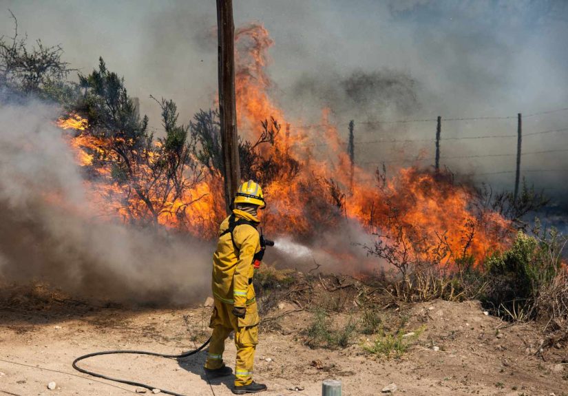
To understand why this technology matters, it helps to think about what these advances feel like in practice. For a dispatcher, an emergency manager, or a firefighter arriving on scene, “faster” is not an abstract tech selling point. It changes the rhythm of the first hour.
Imagine the old pattern. A report comes in from a caller who sees smoke somewhere “past the ridge” or “near the road by the old tower.” The location is vague. Crews roll out, but they are hunting more than attacking. Precious time goes into figuring out whether the report is real, where the flame front actually sits, and whether the smoke column is drifting from the fire or just making everything look farther away. In fast wind, that delay can feel brutal. A fire can move from nuisance to nightmare while everyone is still getting oriented.
Now compare that with a modern, AI-assisted workflow. A camera flags a likely smoke plume. The system estimates a location. A trained watchstander verifies it. A satellite-based alert confirms a heat anomaly. A perimeter starts forming on a shared map. A predictive model suggests the likely direction of spread. Dispatch, air resources, and local agencies are suddenly looking at the same incident picture instead of building one from scratch in separate rooms. The fire is still dangerous, of course, but the response has momentum much earlier.
That kind of experience has already shown up in real wildfire operations. In California, camera networks and modeling tools have helped teams identify ignitions quickly, triangulate location, and generate spread maps within minutes. In utility and public safety settings, AI-based systems have reportedly beaten 911 calls in some cases, giving responders a small but meaningful head start. No firefighter would laugh at an extra ten minutes on a bad fire day. Ten minutes can mean catching a flank before it runs, getting engines into position before roads close, or warning a neighborhood before smoke becomes chaos.
The public experience changes too. Residents do not need futuristic jargon. They need clarity. They need to know whether the fire is actually near them, whether an evacuation warning is likely to escalate, whether the route on their phone is still safe, and whether the smoke in the sky is from a distant incident or the one now threatening their canyon. AI-supported maps and faster public updates can reduce confusion at exactly the moment when confusion is most dangerous.
There is also a quieter emotional side to all this. Better tools reduce the burden on the humans already carrying too much of it. Dispatchers get fewer blind guesses. Watchstanders experience less fatigue from staring at screens hoping to spot the first gray thread of trouble. Incident commanders gain better tactical context sooner. Firefighters heading into rough country do so with more information about terrain, winds, and likely fire behavior. None of that eliminates stress, but it can turn pure uncertainty into informed urgency, and that is a meaningful upgrade.
Of course, nobody on the ground believes software alone will save the day. Crews still cut line, structure protection still requires hard decisions, aircraft still face weather limits, and fire behavior still has a nasty habit of ignoring elegant models. But the lived experience of modern wildfire response is beginning to shift. The first hour is becoming less about searching in the dark and more about acting on shared intelligence. That does not make wildfire easy. It just makes responders less outmatched. And in a world where fires move faster than ever, that may be one of the most important advances of all.
Conclusion
AI advances could help fight wildfires faster because they target the exact moments where wildfire response usually loses time. These tools can spot smoke before many people do, identify heat signatures from space, update fire boundaries more quickly, forecast spread with better detail, and support containment choices under pressure. The best systems are not replacing human expertise. They are amplifying it.
That distinction matters. Wildfire response will always depend on experienced crews, local knowledge, weather awareness, and difficult judgment calls. But as the wildfire threat grows more complex, responders need better tools to keep pace. AI is beginning to offer those tools in practical ways, and the agencies that learn how to use them well may gain the one advantage every fire operation wants more of: time.